Key research findings and final reflections

Following a busy few weeks of write-up and last-minute incorporation of results, my MSc thesis has been submitted! Though challenging at times, it has been an enjoyable and rewarding experience overall. I’m grateful that I got the chance to carry out my placement in Vietnam, and my supervisors in CIAT and NUI Galway were supportive and encouraging throughout.

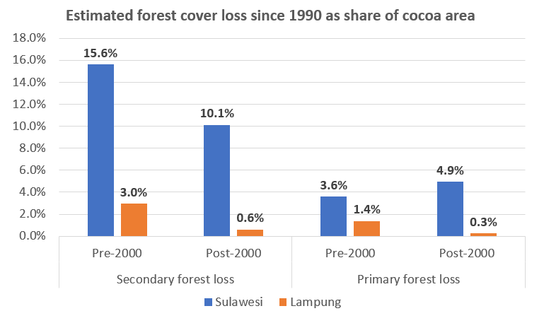
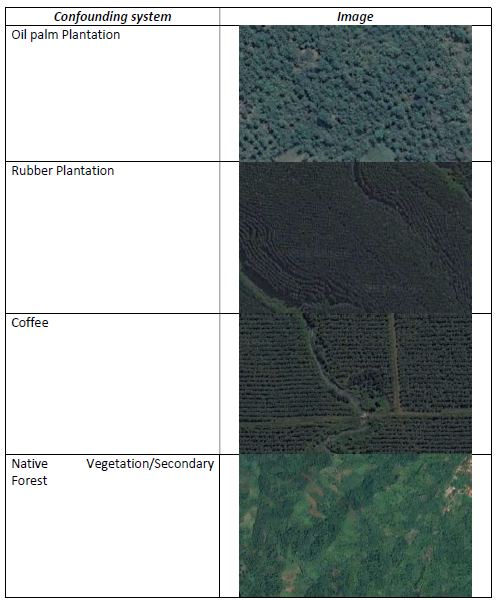
Have a look at the results section for an overview of the key research findings. Continue reading “Key research findings and final reflections”

The importance of definitions in deforestation assessments

How forested land is defined in deforestation assessments has always been a “contentious” issue in Indonesia as the article below from Mongabay describes. International organisations such as the FAO define forest as “land spanning more than 0.5 hectares with trees higher than 5 meters and a canopy cover of more than 10 percent, or trees able to reach these thresholds in situ” (FAO, 2012a). Continue reading “The importance of definitions in deforestation assessments”

Verification of remote sensing data

Verification of remote sensing data is essential to calibrate methods and ensure acceptable levels of accuracy. For this research project the Terra-I remote sensing data was validated using government statistics on cocoa production and knowledge of CIAT colleagues. However field verification is normally the preferred and most accurate (though generally most expensive) validation technique.

The below link is to an informative blog post about a field verification exercise carried out for Terra-I data in the Peruvian Amazon. The data to be validated included over 25,000 ha of land cover loss from between 2004 and April 2015. The verification exercise used Terra-I data for 2013, 2014 and 2015 to define 65 sampling points and then using three buffer zones, randomly selected pixels for field validation.

http://www.terra-i.org/news/news/Validating-Terra-i-in-the-Peruvian-Amazon.html

Final presentation of results to CIAT

This week I got data on cocoa farm areas and primary and secondary deforestation figures for Sulawesi and Lampung and presented a quick assessment of these results to CIAT at a lunchtime presentation yesterday. I will spend more time over the coming days examining the data but this quick assessment (see figure below) showed that about 35% of cocoa areas in Sulawesi were located on areas that were deforested since the 1990s, compared with only about 5% of cocoa areas in Lampung. There may be many reasons for this, which I hope to explore a bit more once I have the Sulawesi data broken down into the four provinces.

Continue reading “Final presentation of results to CIAT”

Project presentation to Irish Aid Vietnam

Yesterday my two classmates, my CIAT supervisor Tiffany Talsma, two of her CIAT colleagues and I met with Irish Aid Vietnam at the Irish Embassy in Hanoi. Irish Aid support the Vietnamese Government’s Socio-Economic Development Plan as well as funding the global CCAFS program. Below is a short Video summary of Irish Aid in Vietnam. Continue reading “Project presentation to Irish Aid Vietnam”

Heatwaves and wildfires: a new reality for Ireland’s forests

The recent spate of wildfires in Ireland following the heatwave are a reminder of how the climate and weather is changing and how it is affecting efforts to protect forests in Ireland. Even the best laid plans to protect forested areas can be brought down in mere days by uncontrollable wildfires. Prolonged hot and dry spells were once a rarity in Ireland but are becoming more frequent and with it come more favorable conditions for wildfires.

The biggest of the recent wildfires was in the Slieve Bloom mountains on the Laois/Offaly border. It had a front of over 4.5 miles and burned for more than a week. Although the full extent of the damage is not yet clear there are estimates of 180 hectares destroyed from this fire alone, with loss of habitats and release of carbon dioxide into the atmosphere slightly more difficult to quantity.

Update on classification results

Time has flown and I’m into my final two weeks at the CIAT office. At the start of the week I had a discussion with the Terra-I team about the challenges and timeline for the national level cocoa classification, given my limited timeframe remaining. I’m hoping to get some cocoa probability maps from them this week.

From the trial runs carried out for the Lampung province, it has been found that the automatic classification system is working quite well at the lower probability end of the cocoa classification. However, at the other end of the scale (positive identification of cocoa), rubber and coffee plantations seem to be the most problematic confounding systems in this region. Coffee and rubber was identified as one of the four most likely confounding systems prior to starting the system training exercise. See figure below of the image interpretation key of the four confounding systems used in the supervised classification.

Continue reading “Update on classification results”

Preliminary cocoa classification results

A trial run for automatic classification of cocoa in the landscape was performed for the Lampung province last week by the Terra-I team. This was following a number of supervised classifications of cocoa which were used to train the system for automatic classification.

The output provided a better understanding of how the system is currently working and how it can be refined. I have a better idea of how the final output is likely to look for my research objective of estimating the spatial distribution and areas. The system is currently set up to identify cocoa within ranges of confidence, see output image below for Lampung with the areas in blue being the least likely to have cocoa and red being the most likely.

Continue reading “Preliminary cocoa classification results”

Estimating aboveground carbon stock in forests: Remote sensing

Following on from the last few blog posts, a third technique for estimating aboveground carbon stocks is through remote sensing. Remote sensing has relevance for my project since we are using it to identify cocoa farm typologies at a large (national) scale and I will indirectly use it to classify the carbon stock of those typologies.

Remote sensing and satellite imagery techniques can cover large ages and can be used for landscape classification when combined with secondary spatial information. Broad forest types at the landscape level and even tree dimensions at the plot level can be estimated which can then be converted into biomass using statistical relationships (Brown, 1997; Chave et al., 2005; Saatchi et al., 2011). Remote sensing techniques can broadly be grouped into categories of optical sensing, high-resolution satellite imagery, microwave or radar, and LiDAR. Continue reading “Estimating aboveground carbon stock in forests: Remote sensing”

Challenges and opportunities for zero deforestation commodities

Recently I came across an interesting discussion item from CIFOR (Center for International Forestry Research) entitled “Are deforestation-free commodities too good to be true?” which nicely summarises the challenges and opportunities for commodities. Continue reading “Challenges and opportunities for zero deforestation commodities”