Final presentation of results to CIAT

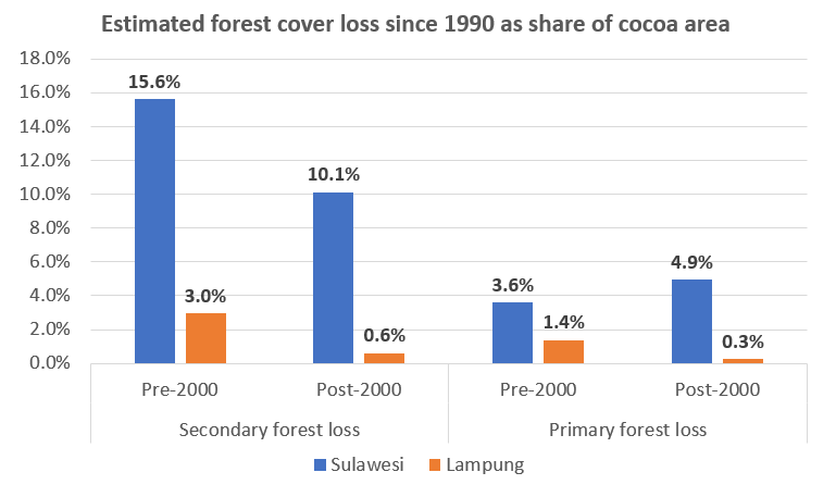
This week I got data on cocoa farm areas and primary and secondary deforestation figures for Sulawesi and Lampung and presented a quick assessment of these results to CIAT at a lunchtime presentation yesterday. I will spend more time over the coming days examining the data but this quick assessment (see figure below) showed that about 35% of cocoa areas in Sulawesi were located on areas that were deforested since the 1990s, compared with only about 5% of cocoa areas in Lampung. There may be many reasons for this, which I hope to explore a bit more once I have the Sulawesi data broken down into the four provinces.

Continue reading “Final presentation of results to CIAT”

Update on classification results

Time has flown and I’m into my final two weeks at the CIAT office. At the start of the week I had a discussion with the Terra-I team about the challenges and timeline for the national level cocoa classification, given my limited timeframe remaining. I’m hoping to get some cocoa probability maps from them this week.

From the trial runs carried out for the Lampung province, it has been found that the automatic classification system is working quite well at the lower probability end of the cocoa classification. However, at the other end of the scale (positive identification of cocoa), rubber and coffee plantations seem to be the most problematic confounding systems in this region. Coffee and rubber was identified as one of the four most likely confounding systems prior to starting the system training exercise. See figure below of the image interpretation key of the four confounding systems used in the supervised classification.

Continue reading “Update on classification results”

Preliminary cocoa classification results

A trial run for automatic classification of cocoa in the landscape was performed for the Lampung province last week by the Terra-I team. This was following a number of supervised classifications of cocoa which were used to train the system for automatic classification.

The output provided a better understanding of how the system is currently working and how it can be refined. I have a better idea of how the final output is likely to look for my research objective of estimating the spatial distribution and areas. The system is currently set up to identify cocoa within ranges of confidence, see output image below for Lampung with the areas in blue being the least likely to have cocoa and red being the most likely.

Continue reading “Preliminary cocoa classification results”