A summary of my Research
Over the past few months we in the CCAFS master’s program in NUIG have been conducting research on our selected projects and now we are coming towards the end of that journey with a little under 2 weeks to go until the final submission is due.
My project changed quite a lot from the being where I was first going to look at land-use changes in Ireland over 100’s of years with a particular interest in forestry, but after meetings with my supervisors we decided that we should look at forestry and creating forest climatic zones for Ireland. This came from an interest to look at how frost risk is affecting the most important commercial tree species in Ireland: Sitka spruce. I wanted to see how Ireland’s changing frost risk would influence site selection for Sitka spruce establishment in Ireland.
The first step was to gather all the information about the subject such as the history of forestry in Ireland, history and physiology of Sitka spruce, Climate Change, afforestation efforts in Ireland, precipitation change, Ireland’s climate and of course how frost affects trees, particularly how it affects Sitka spruce, how frost forms, spring frost and autumn frost. All this information was gathered and formed my literature review.
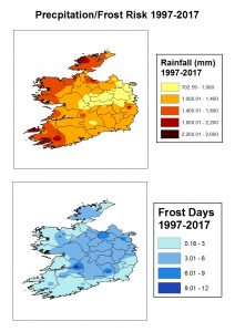
The second step saw me focus on frost risk for Ireland where I gathered my data from my co-supervisor from Teagasc and from Met Éireann’s historical climate database. After discussions with one of my supervisors we agreed that only late spring (April, May), June and early autumn frost (September, October) would be used to calculate frost risk as these are the months where Sitka spruce are most susceptible to frost damage. Over the following few weeks the data was gathered from each station that was used and a map was then created showing these changes over the periods examined and these changes can be seen in the frost risk results page. The results from this research was important as it allows for the identification of the highest frost risk zones in Ireland.
The third step was to identify changing precipitation patterns in Ireland for the period 1957-2017. This was done in a similar way to the frost risk data collection using the Met Éireann database which is open to the public. Data from each station was gathered and input into an excel files which would be later used to create maps showing the precipitation patterns. The results from this part of the research can be found in the precipitation patterns results section. This part of the research was necessary to allow for the creation of forest climatic zones in Ireland.
The final step of this project was to create forest climatic zones for Ireland using data from both frost days and precipitation for the period 1997-2017. This was done by combining frost days and precipitation pattern data together to create a number of zones where frost and precipitation was designated as Low, Medium or High and combing both in an excel file before creating a forest climatic zone map using GIS. The forest climatic zone map and the distinct zones can be seen on the forest climatic zones results page.